
 |
| View of the campground from our dining table |
Following the drama with our “short cut”, we decided to have 2 nights in Cannon Beach instead of our planned single night stay. This allowed us to enjoy a well-earned (and needed) bottle of red wine as I don’t normally have alcohol the night before we travel.
I digress – our plan for the trip on the west coast was to travel all the way down highway 101 from Cannon Beach in Oregon to San Diego, right at the bottom of California on the USA/Mexican border. That included lengthy stops in San Francisco, Los Angeles and many identified tourist spots along the way. Once we had finished on the 101, we were to head north east to Las Vegas, then further inland through Nevada to northern Utah, looping back around towards the south to catch many of their National Parks, and finally head south to Arizona to catch a little warmth.
 We enjoyed the first night in Cannon Beach and went in search of what to see the following day. The weather wasn’t too inviting as it was raining on and off but on the way into town we saw a large rock in the water called the Haystack, and a couple near it called the Needles.
  Off to the beach we went and between showers, walked down the quite large sandy shore to get a few photos. We passed by quite a bit of very long kelp, almost 8 metres long, a couple of dead seagulls and the normal flotsam and jetsam carried by the seas from ships, small Pacific islands and some perhaps all the way from Japan. One thing that also stood out was the large amount of driftwood logs and trees, many of which could be machined up to make some wonderful outdoor furniture.
We ran back towards the car when we saw the rain approaching in an attempt to stay dry, but alas, the rain won the race! To warm up and dry off a little we drove down their quaint main street and found a small but beautiful little coffee shop that also doubled up as a bakery, just what we needed. The girls loved it too as the tables had been designed for kids to draw/scribble on them using chalk.

As Halloween was also fast approaching (October 31st) and it’s such a huge thing here, we needed to plan where we were going to be because Chantelle and Rochelle wanted to do “something” to celebrate. We chose Newport which was only about 160 kilometres further south and they had a campground that was also part of a marina. That would allow us 3 nights in Newport, the last being Sunday night, Halloween.

I can’t imagine the difficulty we would have had to pull our rig across the road to get to a view point, many times there were double lines that would have meant driving further and doing a U turn, twice. So, please allow me to pass on this little gem to anyone planning a similar trip on the USA west coast.

We travelled through Tillamook and Tillamook Bay, famous here for its cheeses and seafood and they have some pretty good wines as well. Other than at Tillamook Bay, the sea appeared to be quite “angry” as long lines of breakers were crashing to the shore. Obviously this was a little unusual because each place we stopped to take photos, many of the locals were also there taking pictures.

We very nearly ran into (literally) a problem when we arrived in Newport’s campground (58). Upon arrival we duly stopped at the designated stop sign near the registration office and walked to the desk to register. Once the documentation was completed and my wallet was made a little lighter, I walked back to the rig.
I was about to climb in when I saw a couple of guys standing near the registration office looking at us –sort of strange looks too. I called out “Hi” and they walked a little closer but stopped, then looked at the building’s veranda and back to me without saying anything. It was only then that I too looked up and read the clearance was 13’4” – we need 13’10”!!! They commented it looked like it was going to be a tight fit, and I confessed I hadn’t even looked up to see the height and that we weren’t going to fit. I thanked them, chastised myself and vowed I wouldn’t do that again....I hope.
 |
| Sunset at the campground/marina & Yaquina bridge |
Newport’s campground was great, once I found my way to where we had been allocated. It’s very large and I drove to the wrong section – twice! Not the same wrong section mind you, about 200 metres apart – I just hope my new neighbours weren’t watching!
Being beside a marina was great and we went for a stroll through there the next day. There were commercial fishing vessels mixed with yachts and motor cruisers which caused me to reflect on how the Statesman’s repairs were going.
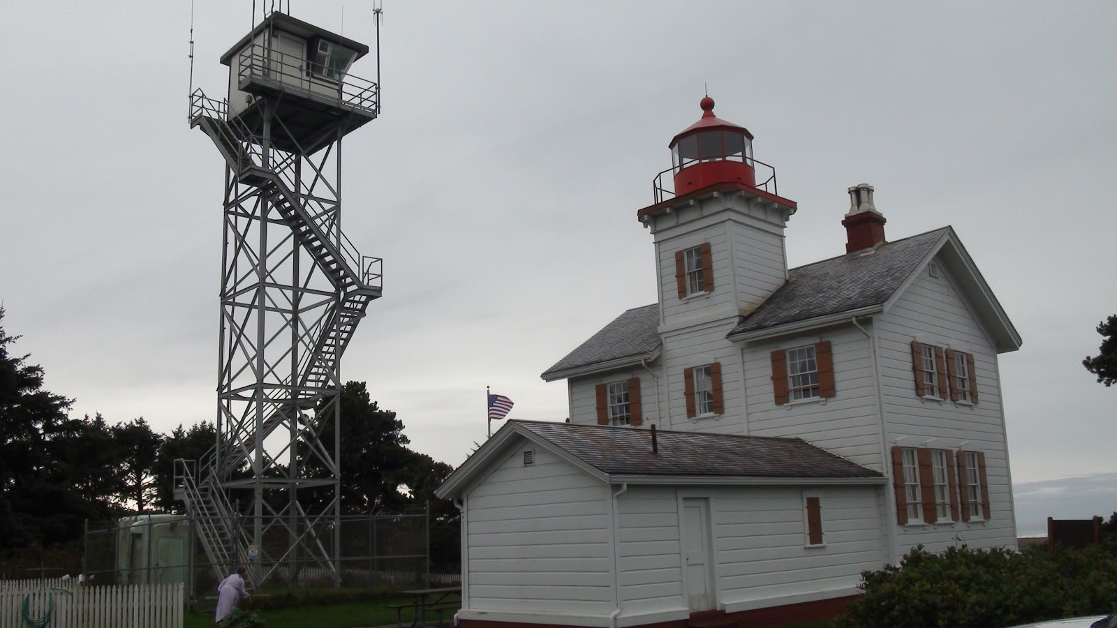 We visited Cape Blanco lighthouse, a small local lighthouse that was built in the late 1800s, was still in operation and was allegedly haunted by Muriel, the ghost of a 16 year old girl. She had been dropped off in Newport by her father who was a sailing ship captain because Muriel had been very seasick, and he was to return for her in 2~3 weeks on their journey back north.
Apparently she befriended some local youths who wanted to visit the lighthouse at night, had accidently left her handkerchief there when they left and was taken back to the lighthouse to retrieve it. She entered the lighthouse alone, an enormous scream was heard and when her friends went inside, she had disappeared leaving only a few spots of blood on the stairs.
To this day, they have painted the stairs many times but the paint won’t cover the spots where the blood was supposedly seen. It is said that Muriel’s dad strangely never returned to pick her up, even though no-one could find him to tell him of his daughter’s disappearance....oooOOOooo
 We went to the local Walmart and purchased Halloween costumes, a mask for Grace (with my wrinkles, grey hair and eye bags I don’t need one), spider’s webs, a large pumpkin and some other Halloween odds and ends. We also found out that local businesses sponsor a “Trick or Treat” event – a couple of hours on Sunday afternoon and into the evening in various locations around Newport and for safety, at least one parent must accompany their child(ren). Every store that was offering gifts had 2 balloons hung outside.

The next day the time arrived for the Trick or Treat adventure and at first the girls were quite timid. However, after quite a number of shops in which we had been watching and listening to the American children as well, their confidence grew and by the end of our second location they had their small bag filled with lollies and chocolates.

 Port Orford (59) was our next destination and this location is almost the furthest west on the mainland of the USA that one can go. On the way down the entire 101 we noticed many signs about the dangers of Tsunamis and where Tsunami evacuation points were located. Seemed fairly obvious to me you'd need to head for higher ground, however, it could be something lawyers here could sue for if people weren't properly advised or warned?
  The Pacific seas continued to pound the shoreline on our way to Port Orford and that sea mist just hung around like, well, sea mist I suppose. We stopped in Yachats to have a look at the Devil's Churn and it sure was churning, however we didn't stop long due to rain showers that were forecast for the day.
The Port Orford campsite was very small and mostly occupied by people who lived there. The chap in charge was very friendly, and although we were only staying the night didn’t mind a chat (or two) and helped us position the rig.
It was during the early evening I pondered the wiseness of my plans to travel through Nevada and Utah in January. When looking at the average temperatures, I found the maximum daily temp was only -1°C and night temps averaged around -12°C. I’m sure I’d looked at these details previously but it was only now that travelling and living in a 5th wheeler at those temperatures sunk in. Snow ploughs are used on interstate highway and most state highways but driving under those conditions worried me.
I searched for both long range and 10 day forecasts for Nevada, Utah and Arizona and they were very good for about the next 8 days. However, a huge cold front was behind the high and they were forecasting temperatures to drop to below average for the year. The long range forecast was suggesting temps colder than average and more snow than usual for the upcoming winter.
Now it was decision time, no windows for procrastination. I planned the new route to go inland immediately and delay our visit to San Francisco and Los Angeles etc. Being pretty nervous about Homer’s choices, I asked the campground manager about the best way for us to head towards Salt Lake City. He suggested taking the I5 and the closest way was for us to backtrack about 50 miles north then inland to meet the I5, then south to Highway 95.
 However, he said that it would be a pity if we did because we would miss the Californian Redwood forests and spectacular scenery along the coast. In fact, the scenery was so good that many films and advertisements had been made along the northern section of the 101 in California. Decision made, south on the 101 through the Redwood forests and hopefully as far as Mendocino which meant driving about 8 hours the next day and a few more long drives to come.
  |
| The amount of driftwood was amazing |
Despite being on a self imposed tight schedule, we still wanted to stop as often as we could to photograph our journey. A major disappointment was the weather; the sea mist was still about and very thick in most places which completely obscured our views of the “beautiful” coastline. From time to time there were clear sections that allowed us small glimpses and we saw the seas were still quite rough.

Shortly after the border we called in to a visitor’s centre and found out about the Humboldt Redwoods State Park which was only a slight deviation from our day’s journey. Within this park they had the Avenue of the Giants that was explained as a “must see”. We learnt that redwoods are the tallest living things on our planet growing 300-350 feet tall with a diameter of 16-18 feet and the tallest recorded soared to 360 feet.

We’re so happy we chose the path south down 101 instead of backtracking when we saw the first of the Redwood forests, they are magnificent. The beauty of the forests along 101 enticed us to visit the Avenue of the Giants detour. Again with many of the sights we’ve seen, it is difficult to properly describe the beauty. The strong smell of pine, the complete silence, the huge 3D shapes of the bark on their trunks and the lack of undergrowth, I suppose due to the available lack of direct sunlight.


Call me suspicious, but after he left I felt uneasy about this stranger offering us a map with a price tag still attached, not wanting money and suggesting we go off the road to look at his suggestions. I’m more than likely too suspicious as he may just have been a very friendly local, however, I didn’t take him up on his kind suggestion.
The area in which we had been admiring turned out to be a “new growth” area and had only been planted in the 1980s. Nevertheless, these were very large – couldn’t wait to see the old growth trees. We arrived at another turnoff to the Avenue of the Giants only to read a sign that there was a maximum vehicle height of 12’ allowed past the sign. Oh well, we had to try to imagine what those huge old growth redwoods would look like because we were unable to enter as we were towing the Sierra.
 |
| We know Homer has misled us occasionaly, but I'm sure Samoa can't be reached by road! |
We didn’t reach Mendocino that night due to our various stops but found a campground at Garberville (60), about 50 kms south of the state forest. The campground turned out to be very empty and quite close to the 101. There was no-one else near us at all and there was no television reception, no cable, no signal on either our American or Australian phones, indeed, no communication at all. For some reason I sat up most of the night, unable to sleep because the lack of communication, and our vulnerability played on my mind like an endless loop.
The next day was again to be a long day but as we were leaving the 101, we thought there wouldn’t be too many stops for photo opportunities. Points 61 and 62 on our path are only to “force” us to take our chosen path, not some great shortcut! The roads again turned out to be an easy drive and once we left the forests, the scenery became quite monotonous with a few exceptions.

We came as close as 160 miles to San Francisco before heading east just north of Sacramento. Once we passed a town called Auburn we started an enormous climb, from sea level almost till we reached Truckee. The available amount of diesel in the fuel tank started dwindling, at first not too much of a problem but as we neared 6000 feet in elevation, had me more than a little concerned.
Our path seemed to plateau for a while then we started to both descend and climb again. We unsuccessfully tried to buy diesel in 3 places as the tank neared empty, and each time we reached another hill I started to become seriously alarmed.

With about 12 kilometres to go to Truckee I felt a little bit more comfortable but then the fuel gauge changed from showing us we could travel another 15 miles to displaying nothing, other than “fuel very low”. We then started what turned out to be a long descent, sometimes quite steep and with plenty of curves.
Grace must have noticed my anxiety and asked me about my problem. I told her about our lack of diesel and if the engine stops, I could expect almost no braking and very difficult steering. That sure didn’t ease the tension in the Chev, you could feel it. I crawled down the 1000 feet or so as slow as possible and saw in the distance a Conoco fuel station that I know sells diesel. Made it!!!! Turns out we only had about ½ a gallon (2 litres) of diesel left in the tank. Time to buy a portable 5 gallon tank!!

The redwoods look amazing. Thats somewhere I would love to go. And thats an awesome travel tip to drive north to south. I never would have thought of that myself.
ReplyDeleteThanks Nona, we're a little disappointed to miss out seeing the old growth redwood trees as one of our neighbours here told us they had 15 adults linking hands that couldn't surround a large tree - it must have been several thousand years old. Certainly worth seeing
ReplyDelete