Search This Blog

Tuesday, September 28, 2010

The road to Hill City, South Dakota (13, overnight in 14 to 15 - under 18)

We drove from Denver pretty much due north through the centre of Colorado heading for an overnight stay at Glendo in Wyoming, then north east to Hill City in South Dakota. The drive was quite easy and once we left sight of the Rocky Mountains a few hours north of Denver, the terrain flattened out through Wyoming to that of flatlands and slow rolling hills covered with Tundra.
From time to time to break the Great Plains there were a few small cliffs we photographed and a few road signs that reminded us of home.

It’s hard to believe with a population of around 260 million people, country areas in USA have miles and miles of plains without being able to see a house or two. More often than not, when you do see houses they seem to be sitting in open land, not surrounded by trees for shade and privacy or wind breaks of any sort.

It wasn’t till we entered the Custer County area in the south west of South Dakota that we caught sight of the Black Hills. Not spectacular at first but large and impressive.

Clearly Homer had been to our RV campground in Hill City before because as we (he) negotiated us towards our campground, he took us through various short cuts, back streets and dirt roads, none of which were appropriate for our rig!


Garden of the Gods (12)

We were fortunate that the Garden of the Gods entrance “happened” upon us in our desperate search for diesel – the Chev’s fuel guage was no longer showing “miles to travel” before it ran out of diesel, just “very low”. The service station turned out to be opposite the Garden’s sign-posted entry.

 We had no booklets or brochures of the Gardens so decided we should try to find the inevitable “gift shop” - and Lo, there it was, built in the Pueblo style which reminded us so much of what we saw in Santa Fe, located at the beginning of a road trail through the Garden. All sorts of expensive trinkets and stuff were for sale including a free brochure about the local area, so I shall plagiarise below.

“The Garden of the Gods was dedicated in 1909 as a free city park. An abundance of plant and animal life can be found throughout its 1,350 acres, as well as the magnificent red sandstone rock formations that have made it world-famous.

Many of these formations are over 300 million years old and were sculpted through time by the forces of nature. The Garden offers the best hiking, picnicking and horseback riding in the region. No trip to Pikes Peak Country is complete without a stop in the Garden of the Gods, a registered national landmark.”

Our late arrival turned out to be another stroke of good fortune because the sun was lower in the west, enhancing the beautiful red sandstone colours.

We first came across Balancing Rock teetering on a small piece of itself and sitting right beside the road. There was a narrow space to take the Chev through and certainly worth a stop and photograph. We drove on further through a one way, very windy but interesting road and came across many wonderful looking sandstone rock formations.

Towards the end of where we decided to find the exit due to the lateness of the afternoon and our journey back to Denver, we stopped at a little “pull out” beside the road to take a last photo. A track wound in from this place and I thought it would be a better shot from in a little further – turned out to be another lucky break as the path led Grace and me to a bounty of sandstone shapes. Disappointingly the girls didn’t see these features as they decided to stay in the Chev because they were already tired from this long day.

Time to leave Colorado Springs, head for a shop somewhere to buy Rochelle a birthday cake and get back to the Sierra to celebrate her 8th birthday.

Next direction, north to South Dakota, Crazy Horse and Mt Rushmore but an overnight stay along the way in Glendo, Wyoming due to the distance to be travelled.

Pike’s Peak (11)

All of us had been looking forward to exploring Pike's Peak from the moment we saw it sitting majestically behind Colorado Springs on our intital journey north. We left Denver at around 8.30 because the drive to Colorado Springs takes around 1 ½ hours and we wanted to try to catch the 10.45 train to the peak.

A cog railway train travels from Manitou Springs, the train base depot at an elevation of 6571 feet to the top of Pike’s Peak at 14,110 feet (4302 metres). Cog trains have been taking tourists up to the peak since 1891.

“Homer” took us directly to the train depot and we arrived at about 10.15 only to find a queue for the 10.45 train. Apparently we had little chance of getting on board as few seats were left (online bookings were the best solution we were told) and those in front of us naturally had first choice – turned out to be the case so we booked for the 12.0 midday service. As the round trip was just over 3 hours, we thought we had blown our chance to see the Garden of the Gods.
The time passed quickly with a little bit of shopping in the gift shop - Grace found a Filipina working there and they chatted amiably in Tagalog for quite some time – followed by morning tea. The girls had never tried some of the delights on offer, so peanut butter and jelly sandwiches it was. They had serious reservations as they imagined “jelly” to be what we know as jelly, and “that surely can’t be mixed with peanut butter!” After dissecting the sandwich they discovered the jelly is really jam….”why don’t they call it jam?”

The train arrived a little early and it was comprised of two carriages, two seats on one side and three on the other. Each set of seats face each other and you can’t move the back of the seat to all face forward, thus some must go up the peak backwards. Leg room wasn’t all that great and they fortunately gave us the 2 x 3 sets of seats facing each other. If you didn’t know the people sitting opposite when you first boarded, you soon would!
The train is manned by two people, the driver and a conductor (ours was Mike), and he chatted through a PA system for the entire trip. He was great and had many of us laughing at times with quick anecdotes as well as very interesting information about the train and environment through which we were passing.

At one stage he asked us all to look out the “two seat side” to have a look at the rock that had fallen onto the track “last week” and that he and the driver had managed to drag the rock off and prop it up in “some” safety beside and above the railway track. They hoped it would stay there but expected that with the train’s vibration, at some stage it would probably fall again. We saw the “rock” that they secured; it was huge, perhaps 4~5 metres in diameter and would have weighed many tonnes. It also appeared to be propped there by a couple of smaller rocks and certainly looked precarious!
He mentioned that we should try to keep warm as, despite the warm weather in Manitou, the temperature would drop about 3~5 degrees F every 2000 ft we climbed - so the temp at the top would be about 30~35 degrees F cooler than at the start.


The train is powered by 4 x diesel engines that are connected to (I don’t know how many) cog(s) in between the train rails. These are of paramount importance as the incline in at least two places was 25%. I tried to take photos of some trees standing vertically to give you an idea of what it felt like in the train.

As we climbed through various types of vegetation, the most noticeable were the Aspin trees – most were turning a beautiful autumn yellow and some had progressed to a burnt orange. The leaves and stems are used for medicinal purposes, sun screen protection and balms.

The panorama unfolding before us as we reached the tree line in the mountains was amazing. The weather was ideal and we could see mountains way into the distance. I’m no good at estimation but Mike our conductor said a particular mountain was about 185 miles away.

At the summit we disembarked and we all had about 30 minutes to walk around before re-boarding for the trip back down. The thinness of the air was very noticeable and most people we spoke to felt the same as we did, dizzy with a slight headache. As we walked about I was noticeably puffing lots more than I could have expected with such little exercise, and I could feel my heart rate had increased substantially.

The trip down for Meryla was terrible because her left ear played up very badly. She has had a punctured eardrum a couple of times during her swimming days and we’ve been to see a specialist who said her eardrum was thicker than normal and that it could cause problems when descending in a plane. We really felt for her on the way down as she was crying with pain - actually the pressure difference would have been worse than experienced in a plane because I understand they are pressurised to 10,000 ft and we were at 14,110.

It was around 3.30 when we got back to the Chev, and despite the 1 ½ hour drive back to Denver, we decided we still had enough time to quickly visit the Garden of the Gods – next blog.

Monday, September 27, 2010

Denver (10 - under 13) and Colorado Springs (11 & 12)

As we had hoped, Dakota Ridge RV Park was a safe and secure place to leave our rig while we were on our cruise.

Despite staying in Denver for six days, we unfortunately didn’t get a chance to look around much at all. This was mainly due to the fact that the girl’s school work was falling behind and we needed to put in a big effort to get their work as up to date as possible.

We imagine Denver city to be like most cities, however we did have a chance to catch glimpses as we drove quite close to the city centre on our way to and from the airport.

We would have like more time to explore Golden, the suburb in which we were staying as it was at the foot of the Rocky Mountains and there were quite a number of mountains trails to explore.

Nevertheless, for Rochelle’s birthday on Sept 14th we thought it best to allow the girls to have a school free day - we wanted to explore Colorado Springs and in particular, the mountain we saw behind the city as we were heading north to Denver prior to our cruise.

We discovered this mountain was called Pike’s Peak, and if we had enough time after exploring that, there was another interesting place to see called Garden of the Gods.

Monday, September 20, 2010

Prince Rupert, British Columbia, Canada

As we neared Prince Rupert, we could see the city was larger than those previously visited. However, as the Norwegian Star didn’t arrive until 4 pm (on time) and we had booked a Sealife Discovery & Crab Extravaganza, we had no time to explore the city. Shortly after coming alongside we had to assemble on the wharf to be taken to a boat for our tour.

It wasn’t a long walk to our boat trip but the tide was out and the ramp down to the pontoon to board our boat was very steep. We learned the difficult way that tides in the region have a 20~24 feet difference between low and high tide. We boarded a 50' motor cruiser which had a fish tank with four divisions in the main cabin area. On the aft was a stainless drum filled with water and boiling away with what we guessed were crabs.

The crew were friendly and we soon cast off to look around the local harbour. Many sections of it reminded me of the Hawkesbury River and we stopped at a couple of spots to drop a crab pot. The girls each handled a live crab and much to their disgust, watched me hold a crab by the legs and break it in two over the stainless guardrail – I was being taught to do this – not some fetish of mine!

In the main cabin, a man was showing everyone the different types of sea animals in the aquarium, many of which were passed around to get the “feel”. There were sea anemomies, sea slugs, starfish, sea cucumbers, crabs etc. When I went outside again, the man at the back was throwing food out to attract some local Bald Eagles. Sure enough, in they came but getting a good photo without a rapid shot SLR camera is difficult....or lucky!

Unfortunately it started to rain lightly and although we were able to take shelter inside, we didn’t see a great deal – being twilight and getting darker didn’t assist. The captain was talking about the local history over the PA system, but it was a little difficult to hear as other passengers were intent on having their own conversations.

Upstairs was the dining area and as we sat down, we were brought a good sized crab each. We were also entitled to a tea, coffee, water or soft drink so we enjoyed the feast – crab sure takes a long time to devour. Shortly after we finished the meal, we arrived back at the wharf, climbed the ramp and walked to the Star. All-in-all it was a pleasant evening, the crew were friendly and the food was good.

Next thing, we were on our way back to Seattle – one day at sea and arrived on Saturday morning at 0530. It all seemed to over in a flash! Once back alongside we caught a taxi to the airport and flew back to Denver to return to our American home.

Davidson Glacier, Glacier Point

Our planned trip while in Skagway was to Davidson Glacier and to get there we travelled by a small (fast) boat and picked up from the beach by an old school bus.

It wasn’t so much of a lovely, sandy beach, it was heaps of small dark pebbles and small broken rock - we found out later it was made up of sediment and broken pieces taken from their original location by the slowly moving glacier.

From the beach landing we were driven past their city centre, a small hut where the nine inhabitants lived for their 6 month stint in Glacier Bay, to another camp area. There we were fitted out with warm, wet weather clothing and life jackets needed for our canoe ride on Davidson Lake to get to the base of Davidson Glacier.

There was general banter and laughter and some looks of ughhh when the toilets were pointed out and that this was everyone’s last chance to go before returning from the glacier. There they were, the old fashioned, outdoor thunderbox complete with a seat over a hole in the ground.

To get to the canoes we first had an easy walk a few hundred metres through a wooded forest primarily of Spruce trees. Emily, our guide for the day explained that if we came across a bear on the way, we shouldn’t look them in the eye, just hold our arms high in a collective group, look really large and tell the really nice bear we were just tourists who don’t have food and wanted it's photo – NO flashes!
Once kitted out in our new gear (Emily lent me a spare, bright purple beanie – clashed with my eye liner, but there you are…) we headed for the lake. The pathway to the canoes took us through quite tall trees without any signs of bears, but a beautiful little shaded forest none-the-less.

When we arrived at the lake Emily checked our life jackets, gave instructions on how to safely get in and out of the canoe and divided us into canoe sized groups. Small world indeed, the other four people (two couples) were from Perth, but travelling on another NCL ship in port at the same time.
As we paddled towards the glacier, Emily commented on the amount of ice in the water that wasn’t there the previous day - obviously a large piece of the glacier had fallen off within the last 24 hours. She managed to retrieve a couple of pieces of ice for us to hold, pass around or lick and said that the pieces of ice would be between 250~800 years old.

The day was perfect again, chilly but loads of sunshine and a perfectly still morning. Emily said that in her 6 month stay, which was to end another week after we were there, she had never seen the lake and reflections look better. She wished she had her camera there, but didn’t so we will be forwarding our pictures to her.

Emily pointed out the changing size of the vegetation - the closer we came to the glacier, the smaller and more sparse the vegetation - this was due to the age of the exposed rock/ground due to the melting of the glacier. Davidson Glacier is melting at a rate of 1 mile/50 years.

The lake itself has only been formed as a result of the glacier melting and is apparently between 100~150 feet deep. The depth of the water varies by a few feet and the day we were there, the water had dropped by 4 feet over the past few weeks. It is not tidal, but as the water is melted water from the glacier, the water level is dependent upon the ambient weather conditions.

As we neared glacier, it became apparent the ice was very dirty and we thought it may have been caused by pollution. Not so; Emily explained the vertical lines are called Medial Moraines. A moraine is a glacially formed accumulation of soil and rock being ground off the supporting valley. This debris may have been plucked off the valley floor as the glacier advanced or it may have fallen off the valley walls as a result of frost wedging or landslide.

Moraines may be composed of debris ranging in size from silt-sized glacial flour to large boulders. Emily pointed out a huge boulder that had been captured and relocated by the moving glacier. The boulder was extruding from the water at least 2~3 meters – depth below the surface?

The climbers are tiny dots towards the
bottom left of the photo
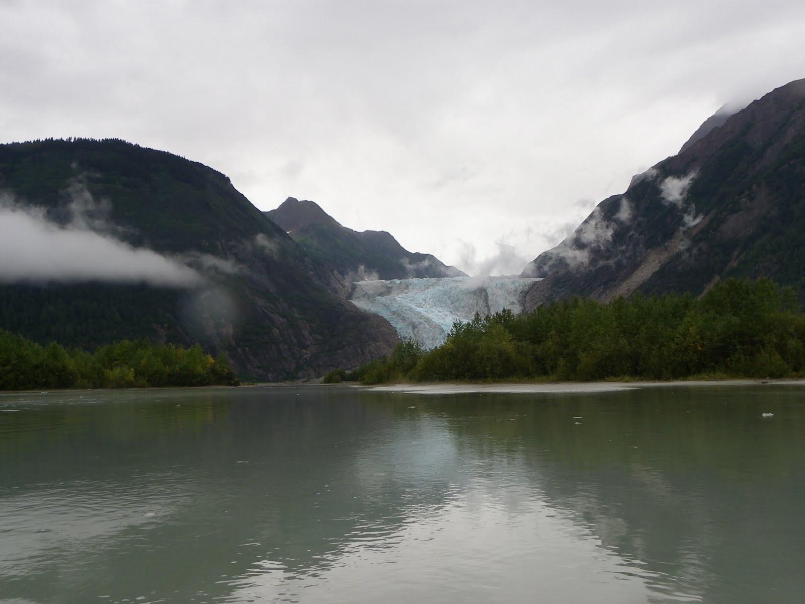
To give a perspective of the scale and size of the glacier, we saw two climbers practicing on the ice. We were taken quite close to a rock wall on the side of the lake, the grey colour is slate and the white, marble. Emily told us to look at the horizontal grooves which had been gouged out of the wall by the moving glacier - and they were very clearly visible.

Sections of the glacier looked quite blue and we learnt that this was due to the density. Snow is about 10% frozen water and the rest is air – due to compression within the iceberg, most of the air has been expelled and the bluer appearance is due to there being about 10% air and 90% water.

Our time there passed very quickly and we headed back in reverse order. As we were driven back to the beach to meet our boat, we were shown Glacier Point International Airport – a section of compacted road the width of a car – mmm, glad we’re going by sea!

Next port tomorrow, Prince Rupert

Skagway, Alaska

A beautiful, quaint town that has a population of about 700 during winter and triples during the tourist season. It survives primarily on the tourist season and has a 23 jewellery shops selling opals, gems they called Aurora Borealis and many others.

Skagway has a historical district of about 100 buildings from the gold rush era. It receives about a million tourists annually, most of whom (about three quarters) come on cruise ships.

The White Pass and Yukon Route still operates its narrow-gauge train around Skagway during the summer months, primarily for tourists.
It has a very colourful history and some incidents are certainly worth re-telling – thoughts go back to Australia’s early years with con men and bush rangers.

Between 1897-1898, Skagway was a lawless town, described by one member of the Northwest Mounted Police as "little better than a hell on earth." Fights, prostitutes and liquor were ever-present on Skagway's streets.

The most colorful resident of this period was bad man Jefferson Randolph "Soapy" Smith. He was a sophisticated swindler who liked to think of himself as a kind and generous benefactor to the needy. He had gracious manners and he gave money to widows and stopped lynchings, while at the same time operating a ring of thieves who swindled prospectors with cards, dice, and the shell game.
His telegraph office charged five dollars to send a message anywhere in the world. Prospectors sent news to their folks back home without realising there was no telegraph service to or from Skagway until 1901.

Smith also controlled a comprehensive spy network, a private militia called the Skaguay Military Company, the newspaper, the Deputy U.S. Marshall and an array of thieves and con-men who roamed about the town.
Smith was shot and killed by Frank Reid and Jesse Murphy on July 8, 1898 in the famed Shootout on Juneau Wharf.
Smith managed to return fire—some accounts claim the two men fired their weapons simultaneously—and Frank Reid died from his wounds twelve days later. Jesse Murphy was actually the one who killed Smith.

Skagway still has remnants of busy times during the gold rush days and grand names such as Broadway, the main street running through the centre of town. Unfortunately, we had little time to explore as Davidson Glacier awaits.

Friday, September 17, 2010

Juneau, Alaska

Due to our late arrival our planned trip was cancelled, however the ship was to stay till 9pm so we still had time to do something. We decided to walk the relatively short distance through the city to the tramway (cable car) and take a ride through the rain forest to the top of Mt Roberts which, at 1,800 feet high sits impressively behind the city.

Once at the top the views are one of the most expansive views in Southeast Alaska: Chilkat Mountains to the north, Gastineau Channel to the south, west to Douglas Island, and east into Silver Bow Basin, where gold was discovered in 1880.

Juneau is set on Gastineau Channel and although it is Alaska’s third largest city, it has a real “small town” atmosphere. I have no idea what the locals look like because we were the fourth cruise ship in port, all at the same time – I don’t know what the collective noun for tourists is, however “swarm” sort of describes it! Perhaps you can suggest a better collective noun?
I was looking forward to the gondola ride up the mountain, but perhaps Grace wasn’t. I had visions of Grace very closely examining the gondola floor (not see through) as she did in a recent trip in the glass sided cable ride up the Blue Mountains near Katoomba. That (to the rest of the family and the other sightseers in the cable-car) was an amusing sight – I noticed someone taking a photo of Grace on the floor in between photos of the view outside.

However, I shouldn’t have worried as Grace was in a particularly bad mood from an incident that happened as we were leaving the ship.
As a result of the earlier incident,
a photo needed to be taken of
every animal we passed!
 I didn’t mention previously, there are ship’s photographers and they try to get as many USD photos of you and the family as possible. The evening prior, we purchased $100 worth of pictures and really didn’t want any more.

As passengers disembark, in each port except Prince Rupert you had to run a gauntlet past the photographer and man inside various animal costumes. They encourage everyone, particularly children to stand with them and our girls did – Grace also tried to photograph the girls with the “seagull” (it was supposed to be an eagle!) and the photographer rudely stuck his hand in front of Grace’s camera spoiling her shot. He was a Filipino and blunt words were exchanged.

That set the scene for our trip up Mt Roberts. Grace stared out the glass window seemingly oblivious to the heights we were reaching, intent on doing something about the photographer!! The view from the top was fantastic, but other than walking along a number of tracks, one back to the bottom, there wasn’t a lot to do.
There was a small theatre in which we watched a very talented family singing and chatting about the local area with a little history, combined with a Powerpoint slide show.
As it was late in the afternoon when we were returning, the family were getting tired but we were still searching the shops for something warmer to wear for our trip to Davidson Glacier tomorrow.

Fortunately we found very nice, warm jackets and clothing all at discounted prices. We are at the end of their tourist season with less than three weeks to go, so the vast majority of shops have substantial discounts – yay, shopping... I’m so glad we were tired, we had to cut the shopping short…